
Lower Colorado River Authority
On July 2, our region was in a serious, years-long drought.
Then came July 3 and the start of heavy rains that caused devastating flooding throughout the Hill Country. By the end of the month, our water supply reservoirs were back to almost full levels.
Welcome to Flash Flood Alley. It’s droughts and floods, and floods and droughts, and then more droughts and then, you guessed it, another flood.
So what happens now that lakes Buchanan and Travis are close to full?
The answer is: Anything.
Droughts, Floods
We could go back to prolonged dry conditions, but it also wouldn’t take much rain for us to have to open floodgates along the Highland Lakes again. Remember – droughts and floods and floods and droughts. With that in mind, I wanted to offer a short primer for newcomers and maybe some old-timers who may be a little rusty on life with almost full lakes.
First, the time to plan for floods is now. Not next month, not next year. Now.
Uncertain Weather
We don’t know what the rest of the year holds, and with rain in the right places, we could see flood operations needed quickly at every dam along the Highland Lakes.
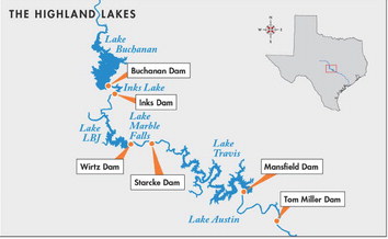
Let me set the stage regarding the Highland Lakes, a chain of lakes northwest of Austin. From north to south, they are Lake Buchanan, Inks Lake, Lake LBJ, Lake Marble Falls, Lake Travis and Lake Austin.
Full Lakes
The two largest lakes – Buchanan and Travis – are water supply reservoirs that are designed to fluctuate. The other lakes are known as “pass-through” lakes built mainly for hydroelectric generation. The passthrough lakes normally are managed within a range of about a foot, but during a flood, flows are much swifter and water levels can be significantly higher.
Lake Buchanan is basically full. That means there is no room to store additional water, so any rain over the lake, or importantly, any rain upstream of the lake, will need to be passed downstream through Buchanan Dam through Inks Lake, Lake LBJ and Lake Marble Falls into Lake Travis, the only one of the Highland Lakes designed to store floodwaters.
And did I mention Lake Travis is just a few feet short of being full?
If Lake Travis rises several more feet, LCRA may need to open floodgates at Mansfield Dam for the first time since 2019 to send floodwater down the Colorado River through Austin and then through Bastrop, Fayette, Colorado, Wharton and Matagorda counties into Matagorda Bay.
If the lower river is already running high, we may need to temporarily store water in the Lake Travis flood pool. (Stay with me here, because this gets a little complicated. Lake Travis is considered “full” at 681 feet above mean sea level (feet msl), but it has a large flood pool above 681 feet msl that can hold an additional 776,000 acre-feet of water, or the equivalent of 31 Lake Austins.)
Flood Risk
That means people on both the Highland Lakes and the lower river need to be ready. Know your flood risk. Develop your plan now.
To be blunt: If you are in an area where you could be affected by floodwaters on the Highland Lakes or Colorado River, you need to pay attention in a way you probably haven’t had to over the last few years. With lakes at these levels, you need to be on alert not just when it rains in your neighborhood, but also when it rains upstream in the lower Colorado River basin, because that water will sooner or later flow into the Highland Lakes.
Be Prepared
Things changed after the July rains, and our region is now in an entirely different operational posture than we were on July 2. Additional flooding could come quickly. We encourage Central Texans to join us in being prepared and ready to act if and when the time comes.
This is not a drill.
John Hofmann is the LCRA Executive Vice President of Water.